Local Authorities across the UK are increasingly challenged by rising rainfall intensity, ageing highway drainage networks, and limited resources for proactive maintenance. The Highway Flood Prioritisation and Risk Appraisal Model provides a practical solution—bringing together GIS mapping technology, real time highway maintenance data, and on-the-ground lived experiences to improve how authorities plan, prioritise, and respond to flood-related issues.
Through data integration and interrogation, Founds Group have developed this methodology as a strategic tool, co-designed with Local Authority Highway and Drainage Leads, to aid flood risk mitigation planning and strategic funding allocation. The ability to visualise flood risk hotspots and utilise drainage data insights is key for Local Authority planning.
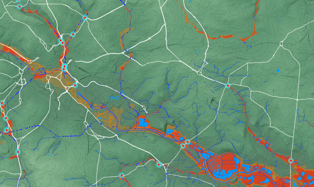
The model enables Local Authorities to combine real-world observations with strategic criteria, helping teams move beyond reactive maintenance and towards data-driven, preventative planning, especially in advance of storm events to mitigate the impact to residents and road users. Analysing flooding hot spots across key transport and road corridors is key for locating priority intervention areas and designing forward and planned drainage programmes.
The model blends datasets such as highway flooding enquiries, emergency callouts, drainage asset records, and jetting works with mapping layers that show where drainage issues have previously occurred or may develop in the future. This creates a more complete understanding of how the highway network behaves during heavy rainfall events, helping teams identify gaps, emerging hotspots, and areas of concern across their region.
By visualising and analysing complex drainage information, the tool empowers Highways, Transport, and Planning teams to make faster and more informed decisions. Whether evaluating maintenance needs, planning capital works, or shaping long-term resilience strategies, the model ensures that choices are rooted in evidence rather than assumptions.
The methodology utilises existing asset management systems already being used by many Local Authorities and their respective term maintenance Contractors. These tools can identify single asset type priorities but lack the ability to optimise preventative programmes linking prioritisation with resilience criteria and allowing strategic decisions to be made. Combining both tools provides an easy to use approach that can be quickly and easily visualised. “You don’t need to be a Q-GIS expert to interpret or use the mapping system”, says GIS and Data Lead at Founds Group – Alana Gaughan. “The Q-GIS is more for analysis and visually representing the data, and it’s very simple to interrogate and produce comprehensive reports”.
The tool doesn’t just highlight risks-it helps strengthen internal collaboration. GIS-driven data insights give different teams a shared understanding of the real highway conditions and flooding pressures, supporting more joined-up conversations and cross-departmental planning. This leads to more coordinated interventions, more efficient use of resources, and much better protection for residents and the public.
Founds Group are looking forward to expanding and building on its current coverage across various Authorities and contributing in its own way to resilience and climate adaptation challenges.